Tracker
Bab el-Mandeb shipping: the latest satellite pass
Ships are still passing. Three large vessels are visible in the strait's western channel in the Sentinel-2 picture of 5 November 2026, against eight on a clear day in October 2023, before the attacks on shipping began. Here are the pictures, a map, and the Red Sea route's status with dated sources.
Is the Bab el-Mandeb closed?
No. Ships are passing, in smaller numbers than before November 2023, and with one stated exception. What can be said, with dates:
5 November 2026, Sentinel-2 pass: three large vessels visible in the western channel (pictures below).
October 2026: the Suez Canal handled 1,490 ships, up from 1,128 in October 2025, and its revenue rose 94% year on year to $724 million (Al-Monitor). Ships between Suez and the Indian Ocean have to pass the Bab el-Mandeb.
11 September 2026: Houthi forces reached Perim Island, in the strait, and their spokesman said navigation remained safe except for Saudi vessels under a previously announced ban (gCaptain).
Map of the Bab el-Mandeb from the latest pass
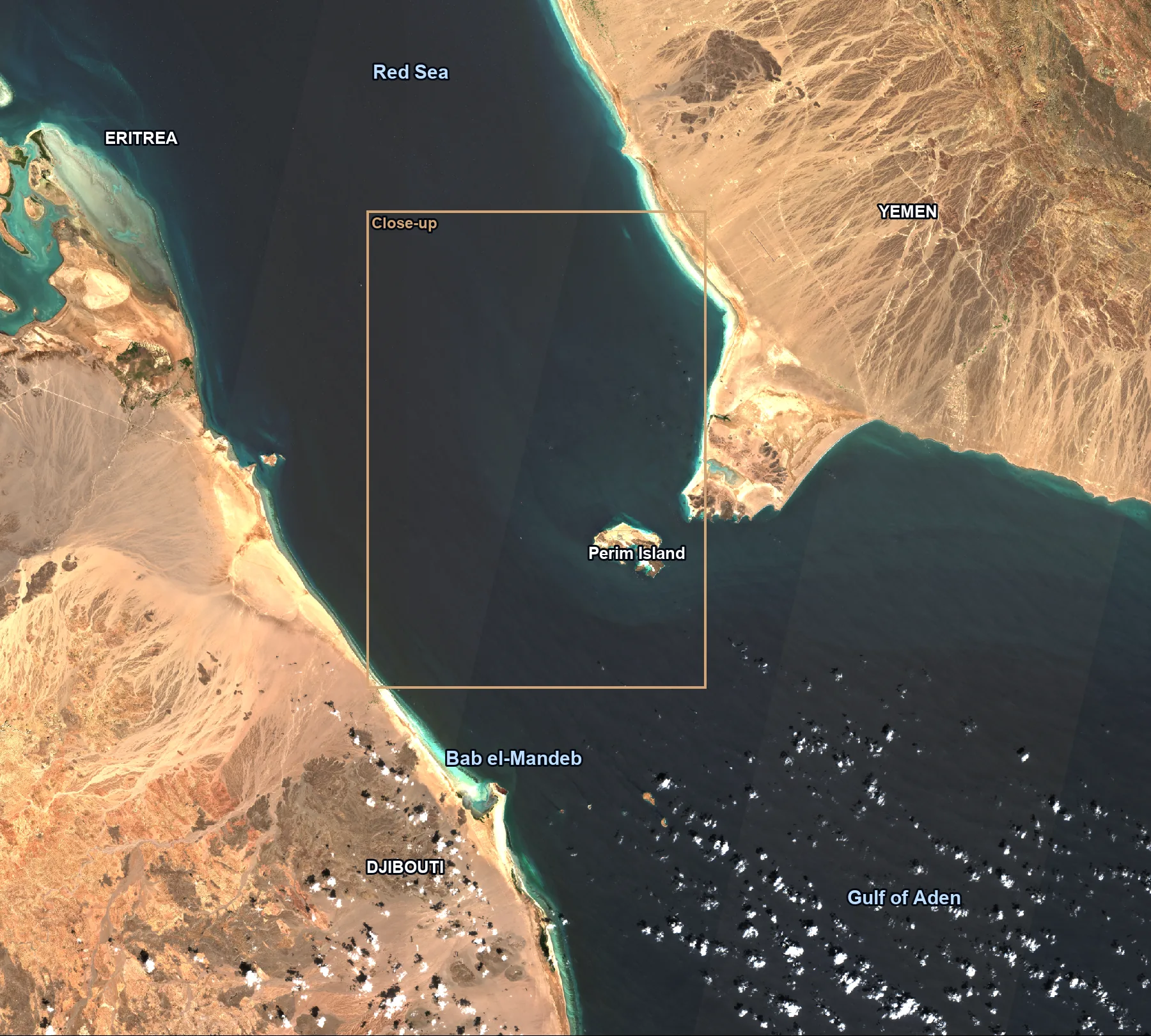
The Bab el-Mandeb joins the Red Sea to the Gulf of Aden, between Yemen on one side and Eritrea and Djibouti on the other. It is 18 miles wide at its narrowest, which limits tanker traffic to two channels two miles wide, one inbound and one outbound (EIA). Perim Island sits in the middle; the shipping lanes run through the wider channel to its west.
This picture comes from the Sentinel-2C pass at 07:46 UTC on 5 November 2026. The gold box marks the close-up further down.
The western channel before the attacks
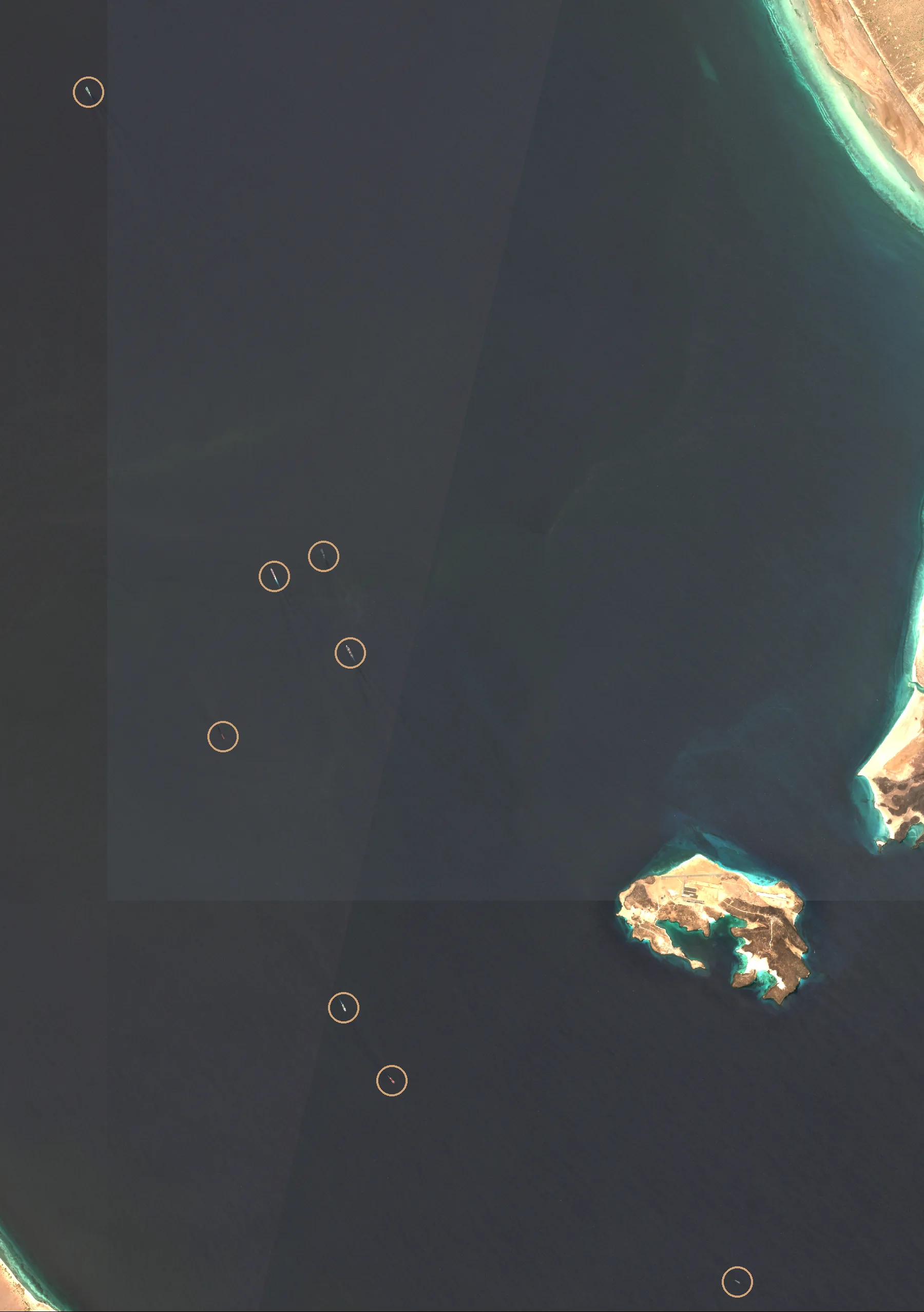
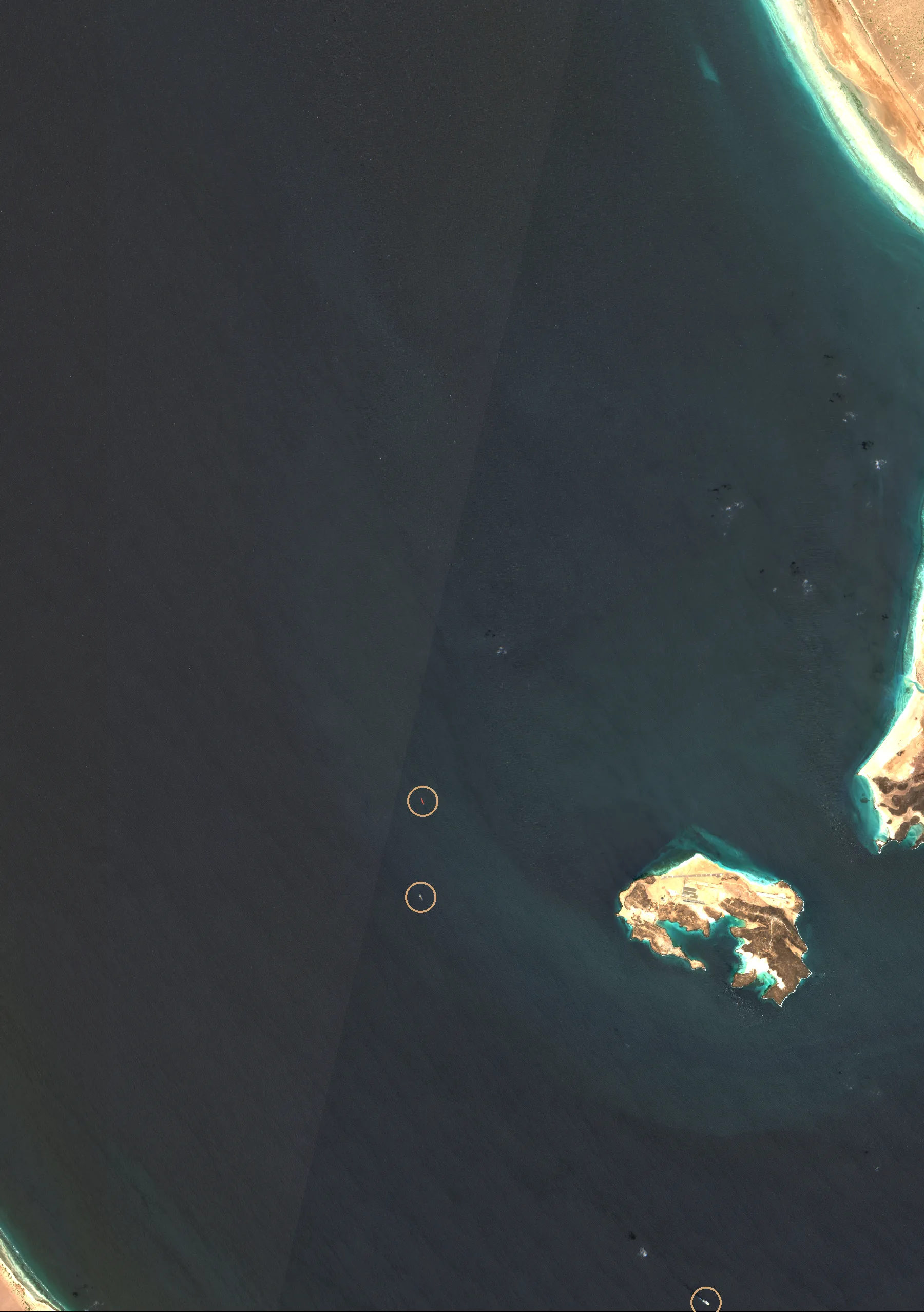
The close-up covers about 27 by 39 kilometres of the western channel and Perim Island. Both pictures come from the same Sentinel-2 area at the same time of day.
On 7 October 2023, a month before the Houthi attacks on shipping began, eight large vessels are visible in the window. Each one is circled.
And on 5 November 2026
On 5 November 2026, three large vessels are visible in the same window, circled. The dark specks on the right are cloud shadows.
This is one window at one moment, not a count of the day's traffic. Single pictures vary from day to day, and ships cross a window this size in an hour or two.
How much oil goes through the Bab el-Mandeb
Oil flows more than halved after the attacks began: 9.3 million barrels a day in 2023, then 4.1 million in 2024 and 4.2 million in the first half of 2025 (EIA).
They have risen during the Gulf war, as oil shipments were diverted to the Red Sea after the Strait of Hormuz closed (Al Jazeera): 5.4 million barrels a day in the last quarter of 2025, 5.6 million in the first quarter of 2026 and 8.1 million in the second (EIA).
Suez, the Cape and the long way round
After the attacks began in November 2023, some ships switched to the longer route around the Cape of Good Hope, which avoids both the Bab el-Mandeb and the Suez Canal (EIA). In the first half of 2025 about 9.1 million barrels a day of oil went round the Cape, 11% of all seaborne oil, and EIA estimates the diversion adds about 15 days from the Arabian Sea to Europe.
The latest EIA figure for the Cape is 9.4 million barrels a day, in the second quarter of 2026 (EIA).
Attacks and events since 2023
November 2023: Houthi attacks on commercial ships in the Red Sea begin (EIA).
20 July 2026: the Houthis impose a maritime blockade on Saudi Arabia, and reports emerge of a plan to charge tolls on shipping through the strait (Al Jazeera). Those reports describe a plan, not a toll being collected.
30 July 2026: Saudi Arabia says 13 countries have agreed to join a coalition to protect Red Sea shipping (Al Jazeera).
11 September 2026: Houthi forces reach Perim Island (gCaptain).
How these pictures are made, and their limits
The pictures are true-colour Sentinel-2 Level-2A images from the EU's Copernicus programme, read from the open Earth Search catalogue. Sentinel-2 revisits a point every five days at the equator with two satellites, and in 2026 a third is still flying (ESA). Each picture is dated to its pass, not to the day this page was published.
Cloud, haze and sun glint hide ships, and small boats may not show at 10 metres. Ships circled in the pictures were checked by eye at full resolution. They are not an automated count.
Questions
Keep reading
Strait of Hormuz tracker: satellite pictures of the strait's lanes against a year earlier, and why the ship counts disagree.
Red Sea briefings: sourced analysis of the Red Sea, Hormuz and Gulf terminals.
Aureum Track: boards with a reading after each clear satellite pass.
Follow the Bab el-Mandeb tracker
Get the strait's reading after each clear satellite pass, with the history kept in one place. Free to join during the beta.